A Guide to Topographic Surveys

If you are planning on setting up a business on a piece of land, one of your first steps will be a topographic survey. This type of property surveying will outline the terrain, including all of the natural and manmade features on the parcel. Understand what these surveys are to know what to expect and why they are important before you start your planning.
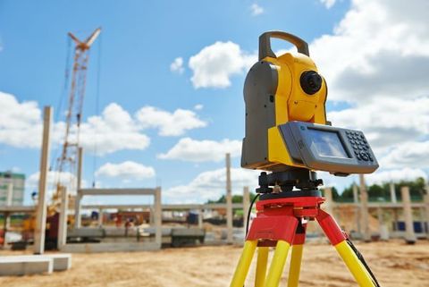
How the Map is Produced
Property surveying is conducted using a GPS and a total station theodolite (TST), which measures the distance between two points by emitting wavelengths of unique frequencies. The number of wavelengths taken to travel between the two points provides an accurate distance measurement. With these tools, the surveyor creates a string of survey points, noting the elevation and location of each.
Once they leave the site, they process those survey points to create a topographical map. This map will provide the requested level of detail and accuracy, showing the height, depth, size, and location of all of the features on the land and the contours in elevation. These features could include roads, rivers, lakes, boundaries, water wells, and buildings.
Why It’s Used
 These surveys are used in preparation for all types of projects on natural land, including new construction, property improvements, and setting up grading. Grading is the process of moving soil to change the slope of land, often in preparation for building a structure. It is also generally required by a zoning office or title company when land originally developed for one purpose is used for another, such as an originally residential lot being re-zoned for commercial purposes.
Property is never perfectly flat and bare, whether it has been built on before or is completely natural. Your architect will need accurate data on the layout of the land as they plan for construction, so they can build around it or make changes to the land. Any land contours or features that are not planned for could cause significant delays and expensive setbacks.
The professionals at Raber Surveying are known for their detailed, accurate, and timely property surveying services in Summerdale, AL, and throughout Baldwin County. Services include everything you need to prepare for your project, such as detailing property lines, topographic surveys, fence staking, flood elevation certificates, and more. See the full list on their website and call (251) 975-7525 to request an estimate.
About the Business

