Why You Might Need an ALTA Survey

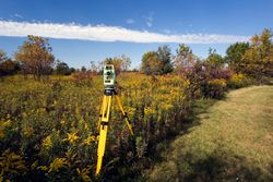
When you need to know the official lay of the land, consider hiring a professional to complete a property survey. However, not all surveys are created equal. Surveys that comply with the standards of the American Land Title Association (ALTA) will offer more respected results than a typical boundary survey. Use the following guide to learn more about this specific land surveying technique.
A Guide to ALTA Surveys
What Is an ALTA Survey?
Because ALTA surveys must align with a strict set of criteria, they reveal a more complete and detailed picture of the properties they illustrate. Not only do they highlight the boundaries of the property, but they also depict any encroachments from neighbors, the names of these neighbors, changes or improvements made to the property, significant features on the property—such as roads, ponds, or burial sites—and main access points.
An ALTA land survey will also specify the zoning classification of the property, whether it has been approved for residential, commercial, or industrial use, and whether or not it is in a flood-prone area.
Why Would You Need One?
 These precise land surveying details make ALTA surveys useful in many more situations, including negotiations or legal conflicts. If you’re planning on buying a vacant piece of land, an ALTA survey may be required by the local government to rule out any boundary issues with past owners or current neighbors. By getting a final answer prior to the purchase, you can avoid legal battles in the future.
You might also invest in an ALTA survey if you are buying or selling a piece of commercial real estate. Not only are details like flood zone classification crucial to business, but they could also affect the final listing price. For example, if a cemetery was uncovered through the survey, the buyer may no longer be interested in housing their business on top of a burial ground.
If you're interested in pursuing an ALTA survey, reach out to Abercrombie & Associates Inc. in Cincinnati, OH. These professionals have been mapping out properties for residential and commercial clients since 1976. As land development and civil engineering specialists, you can trust their concentrated skills to deliver accurate results. To learn more about this land surveying team, visit their website or call (513) 385-5757.
About the Business

