How Geoscientists Study Drought

A geoscientist is a professional who studies the earth’s terrain to learn about changes or trends that may impact the area. This type of study helps local governments and decision-makers understand drought patterns and their potential impact. Use this guide to understand how these scientists look into drought factors.
What Factors Geoscientists Consider
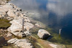
Geoscientists often start by measuring the actual moisture within the soil to determine whether or not a drought is occurring. Water levels may be lower than usual because of evaporation, water seeping too far below the surface, and lack of rainfall. They may also look at water levels in nearby streams or other bodies of water—if they’ve gone down significantly, it may indicate a drought.
Additionally, they can use tools like rain gauges and thermometers to track ongoing weather conditions. Finally, geoscientists can also look back at historical weather information for the region to identify trends that may be relevant to the current situation.
They first have to determine what a normal amount of rainfall for the region looks like and consider factors that may have caused droughts in the past, like fluctuating land temperatures or shifting weather patterns and air circulation.
What They Determine With This Information
 Using the data they collect, geoscientists can determine the impact that a drought might have on the region. For example, is it severe enough to impede crop growth or harm existing plants in the area?
They may also be able to predict how long a drought might last based on things like changing land and water temperatures. Finally, continuing to monitor those land and weather conditions going forward can help to predict when future droughts are likely to occur.
If you’re looking for a geoscientist to evaluate drought or land conditions, contact GeoTek Alaska in Anchorage. The team of geo-technical drilling contractors provides a wide array of services to property owners and government agencies throughout the region, including auger drilling, well monitoring, and utility screening. They have access to small rigs that are easy to transport to remote locations, and they provide environmentally friendly service that doesn’t disrupt the local terrain. Visit the website to see a full list of services or call (907) 569-5900.
