An Introduction to Topographic Surveys

There are several industries in which it’s useful to undertake an in-depth examination of a property’s terrain. Using a topographic survey, developers, contractors, and engineers can better understand the intricacies of their properties. Here’s what you need to know about this innovative process.
What Is a Topographic Survey?
 Topography refers to the study of the many features and shapes that characterize a parcel of land. Surveying divulges comprehensive data about the natural and manmade elements of the landscape. Common features include trees, ditches, fences, drains, pathways, buildings, and bodies of water.
Advanced surveying methods make it possible for professionals to produce three-dimensional models that reveal details about everything from roads to rivers. The resulting survey provides the consumer with information about grading and land elevations, allowing them to plan their projects with greater precision.
How the Process Is Performed
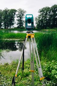
While conducting topographic surveys, professionals employ a methodical approach. The initial assessment determines the positions of different points on a horizontal plane; so long as these points are relative to one another, they may be useful to the consumer in planning their project. The next determination is the land’s elevation. Once these controls are measured, a map can be created with information that computes these distances, the differences in elevation and angles, and the direction of all observed features.
Why It’s Useful
Architects and engineers on the cusp of developing a project generally require a topographic survey before work can begin. It’s essential to know the details of the parcel before planning for a permanent structure to ensure successful construction. The information provided can also be used to make changes to the land’s grading, to create new drainage systems, or to dig new ditches or other permanent features.
Contractors and homeowners alike can trust in the highly qualified team at D & S Land Surveying Inc in Tate, GA, for their land surveying needs. The company proudly serves clients throughout North Georgia and the Atlanta Metro area. They offer topographic surveys, construction surveys, and property line staking, among many other services. Visit them online for further information or call (770) 720-4443 to speak with a representative.
About the Business

