How GPS Has Improved Land Surveying

Land surveying is the process of identifying legal property boundaries, which is essential prior to new construction or property improvements. It is also used to determine property ownership in the event of a dispute or before buying land to avoid issues with encroachments. GPS technology has helped streamline land surveying by providing accurate information from satellite signals. The following explains the value of using GPS for a land surveyor or property owner.
How Is GPS Used for Land Surveying?
 GPS satellites orbit the globe to provide precise points of reference to any given object. GPS receivers obtain signals from several satellites at a time, giving land surveyors the highly accurate data they need to create land maps and determine legal property boundaries. Extra satellites are used when obstructions that reduce reception such as buildings or tree groves are present.
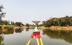
Land surveyors use GPS technology in several ways. Static GPS allows surveyors to record information about two different survey points at the same time over 20-minute intervals. Real-Time Kinematic (RTK) observations involve the base station that remains in place on the ground and the rover station that calculates distances and other information between the two survey points. Continuously Operating Reference Stations (CORS) involve permanent receiver installations providing foundations for survey points within a district, such as for a mining site or local government project.
How Does GPS Help?
GPS technology allows land surveying teams to collect information over larger areas instead of being limited to what they and their ground equipment can see from remote locations such as hills and plateaus.
Satellites with sonar depth technology are especially welcome in coastal and waterway survey projects. Not only are these areas challenging to survey because there are so few viable locations for land surveyors to utilize, but surveyors also cannot manually identify natural and human-made underwater hazards or provide information about water depth at high and low tide. Bridge building and other underwater construction projects use GPS information to create sturdy, safe structures.
Mid-Penn Engineering in Lewisburg, PA, provides the highest-quality land surveying services using GPS technology. Aerial imaging has long been part of this civil engineering firm’s services to both residential and commercial clients to create computer-aided models and drafts. Call (570) 524-2214 today to schedule a consultation or visit the locally owned business with over 48 years of experience online.
