3 Key Pieces of Equipment on a Land Surveyor’s Tripod

When property developers are seeking out sites, one of the first steps is assessing the topography of a given piece of land. They hire land surveying specialists who use special equipment to provide an overview. Most people have driven past surveyors setting up their special tripods at some point, but not many know what exactly sits on top of them. There are three important components to help present the most precise views. Here’s an overview of those pieces of equipment and their unique roles.
Essential Equipment Used by Land Surveyors
1. Theodolite
This is a type of telescope attached to the tripod’s base that’s used to locate horizontal and vertical angles during land surveying. The theodolite has a component called an internal spirit that ensures it’s aligned with the horizon. Surveyors also rely on the optical plummet on the theodolite for an exact vertical marker at the survey point. Once the imagery is recorded, digital versions provide a readout of the survey’s measurements.
2. Total Station
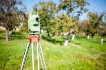 A land surveying tripod also contains a total station, which is designed to determine slope distance. Measurements are taken from the tripod of various areas through mapping software. The total station can record high-resolution images so that developers are able to view sharp visuals of the land’s habitat. In addition, screen views are also available right on-site.
3. Transit Level
When precise measurements of angles are needed, the transit level provides these essential figures. It’s a type of telescope that’s equipped with a spirit level mounted on the land surveying tripod. Transit levels create a reference line that surveys objects, line positions, and angles. all of these components add up to an essential precision relied upon by many industries.
For nearly 20 years, Raber Surveying in Summerdale, AL, has provided expert land surveying for commercial and residential sites throughout Baldwin County. The team of licensed specialists has extensive experience and state-of-the-art equipment to provide precise and high-definition imagery. When you need their professional service, call (251) 975-7525 to schedule a consultation. Visit the website for information on the full suite of surveying services.
About the Business

