Common Questions About Land Surveying

People often encounter land surveying when deciding to sell or purchase property for residential or commercial use. This process provides information on property boundaries that’s crucial in real estate sales and can be helpful for areas that have not been surveyed recently. Here is a guide to some frequently asked questions about this service to help you understand what it is and why it’s important.
An Introduction to Land Surveying
When should I get land surveying done?
If you’re considering purchasing a property, schedule a land survey to assess the borders. This way you’ll know where your property ends and the neighbor’s begins, and you can safely build without encroaching on their land. Plus, you’ll be sure that you’re offering a reasonable price for the property based on the information provided by the surveyor.
What tools do surveyors use?
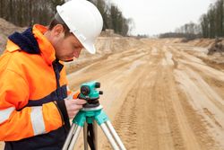 During the land surveying process, technicians will use measuring tapes, existing maps, and deeds as well as more high-tech devices. They may rely on GPS systems to map the coordinates of your property and use a theodolite to assess the angles of the border lines.
What information will a land survey provide?
The results of a land survey typically include a description of the property in the eyes of the law along with records the surveyor used to measure and document the borders of the land. The surveyor may provide their notes along with a plat map that is then entered into public record.
What rules do surveyors follow?
Each area has specific regulations regarding land surveying. These may include local state, county, and city laws and codes that must be followed for the survey results to be considered official documents that can be used in real estate sales and transfers. You can ask land surveying companies you’re considering hiring about how they follow these regulations to help choose the best company for the job.
Those looking for commercial or residential land surveying should contact Raber Surveying in Baldwin County, AL. The experienced team has been in business since 1999 and offers efficient, reliable services and meticulous mapping. Call (251) 975-7525 or visit the website for information on their land and lot surveying, quantity and topography surveying, flood elevation certificates, and more.
About the Business

