What Is a Topographic Survey?

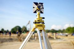
In the beginning stages of a construction project, a professional land surveyor is often hired to conduct a topographic survey. This is a 2D representation of a 3D land site and includes detailed data to map the contours and features of the ground. Here, the professional surveyors at Ferguson & Foss Professional Land Surveyors PC in Johnstown, NY, discuss the most common elements of a topographic survey.
Contours
Contour lines are used to determine the elevation of the peaks, valleys, hills and slopes of the land. When there is slope on a property, a contour line represents a drop in elevation; the exact measurement representations are determined by the surveyor. The steeper the slope, the closer the contour lines.
Vegetation & Physical Features
 A topographic map also identifies vegetation like wooded areas and physical features such as lakes, creeks, and swamps. Blue is typically used for bodies of water, while green is used for forests. The client can also ask for specific requests of the type of features they wish to have highlighted on their map.
Utilities
Utility markings are critical because architects need to know where existing features are located so they can avoid interfering with them. Above-ground and underground features such as street lights, electric boxes, cable lines, and sewage systems must be visible on the drawing. A land surveyor will use various markings to represent each type of feature and then explain it to the architect.
If you’re scheduled to begin a construction project and need a topographic survey for design and planning purposes, turn to a skilled land surveyor for help. The team at Ferguson & Foss Professional Land Surveyors PC in Johnstown will map out a detailed survey and ensure you understand the data. Call (518) 762-9997 to schedule an appointment or visit their website for more information about their full range of services.
About the Business

