Your Questions About Land Surveyors Answered

At some point or another, you may have seen someone standing at the edge of a property with a device resembling a camera. Chances are, you encountered a land surveyor. These individuals lay the groundwork for construction projects by mapping out territories for residential and commercial properties. Many individuals would like to know more about what these professionals do and why, so Ogletree and Chivers Land Surveyors, a land planning service in Milledgeville, GA, is here to answer some common questions.
FAQ About Land Surveying
What Exactly Do Surveyors Do?
Surveyors help project planners and property owners understand boundaries of a plot. They can also shed light on existing land easements and local ordinances, which can be helpful for constructing buildings, lots, driveways, and other property features. Unless you already have a valid survey in your possession, this service may be needed to ensure any construction is performed legally and safely.
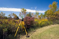
How Is Land Assessed?
A surveyor will visit the property and use specialized equipment to formulate a three-dimensional image of the site. This will include all boundaries, and they will also note any safety concerns that need to be addressed prior to land development. All of the data will be compiled and kept on file by the surveyor and local government so it can be referred back to during construction.
Which Type of Survey Would I Need?
 Surveys are often requested by homeowners when they’re planning to construct a fence, shed, driveway, or similar project. They play an important role in preventing encroachments on neighboring territories, and subsequently, avoiding disputes. For commercial projects, surveys are needed to ensure dwellings and property features are constructed according to local codes, and to help project planners determine if easements are necessary.
How Long Are Surveys Valid For?
Once you’ve received a copy of your survey, you should keep it indefinitely, as they are valid until the property is altered. They are typically given along with other legal documents such as deeds and easements during land transfers. The local courthouse should also have one on file.
If you’re seeking land surveyors with a longstanding reputation for accuracy and quality service, look no further than Ogletree and Chivers Land Surveyors. Serving Eatonton, Gordon, Irwin, and Gray, GA, their team uses the latest software to deliver reliable results. Call (478) 453-3454 to schedule an appointment, or visit their website to learn more about services.
About the Business

