FAQs About Aerial Imaging

From construction planning to property surveying, there are plenty of reasons to take bird’s-eye photos of the landscape. According to the staff at Mid-Penn Engineering in Lewisburg, PA, advancements in technology have improved aerial imaging capabilities, making it virtually effortless to capture specific areas from a wide range of vantage points. Below, their staff answers four questions about aerial imaging.
What You Need to Know About Aerial Imaging
Can Equipment Be Controlled From the Ground?
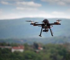 The unmanned aerial vehicles, also known as UAVs or drones, used to capture imagery can be controlled from the ground. The ground-control station is linked to a satellite feed that allows operators to adjust the pan, tilt, and roll of the equipment. Real-time footage can be viewed on ground-level monitors.
Are There Safety Measures in Place to Keep Gear from Crashing?
Although UAV operators are trained to avoid damaging equipment on telephone wires, tree limbs, and additional obstacles, there are safety measures in place to prevent crashes. The devices include built-in GPS and autopilot features, which navigate cameras back to starting locations if radio signals are lost. The multirotor configuration helps land equipment safely if a motor malfunctions.
What Are the Ideal Weather Conditions for Aerial Imaging Projects?
To operate equipment safely and capture the best images, UAVs should be flown when winds are no more than 20 mph. To prevent sensor damage, they shouldn’t be flown during heavy rainfall. Best results occur on days with no precipitation.
Why Should I Hire Aerial Imaging Professionals?
Although many people own drones, it’s still best to enlist a professional for aerial imaging projects. They are trained in UAV system photography, videography, and editing capabilities, as well as equipment operation to ensure high-quality results.
If you need aerial imaging, land surveying, or engineering services for a building design, construction development, or site-preplanning project in the Lewisburg area, Mid-Penn Engineering will assist. To discuss your needs, call (570) 524-2214 to speak with a representative. Visit the company online for a complete breakdown of the aerial imaging services they provide, and like them on Facebook for current news and updates.
