Why Should You Have a GPS Survey Conducted?

Surveys have been used for centuries to map areas and get a better understanding of the local terrain. With the advent of recent technology, however, the ability to precisely map an area has increased. A GPS survey integrates navigation technology into the process, which carries several benefits. McCarty Associates are the leaders in architectural design, engineering, and surveying. After serving Hillsboro, OH, for over half a century, they have a few reasons to suggest a GPS survey when you’re mapping out an area.
Among the most obvious ways that a GPS survey can benefit you is through the savings of both time and money. First, during the course of a survey, the expert needs to visit a location several times to assess the area and verify their data. When GPS technology is used, it can make data verification a speedier procedure and reduce the labor costs. This equals less time consumed and less money invested.
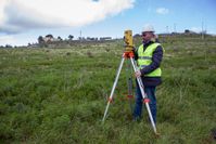 Weather conditions can interrupt and delay this process as well. GPS technology allows surveying to be conducted regardless of the temperature or distractions, like rain and snow. GPS tools also allow surveyors to collect data without having to worry about the line of site. Overall, it allows surveyors to work without having to worry about the distractions that would have hampered the process before such technology was available.
Whether you’re in need of surveying services or need to consult with architectural engineers, McCarty Associates employs highly trained professionals that can answer any questions you might have. They bring the latest tools to any job and can help you save money in the long run. If you have any further questions about how they can assist you, call (937) 393-9971 or visit them online.
About the Business

